Skip over navigation


Start Content
Delaware County, Indiana
Discover Delaware County - an east central Indiana community of opportunity
Contact Us

Kyle Johnson,
Chief Information Officer
Chief Information Officer
- Phone: (765) 213-1269
- Staff Directory
- Office Hours:
8:30am-4:30pm
Lunch Hour varies, call for appointment
In this Department
About GIS
How is GIS used in Delaware County?
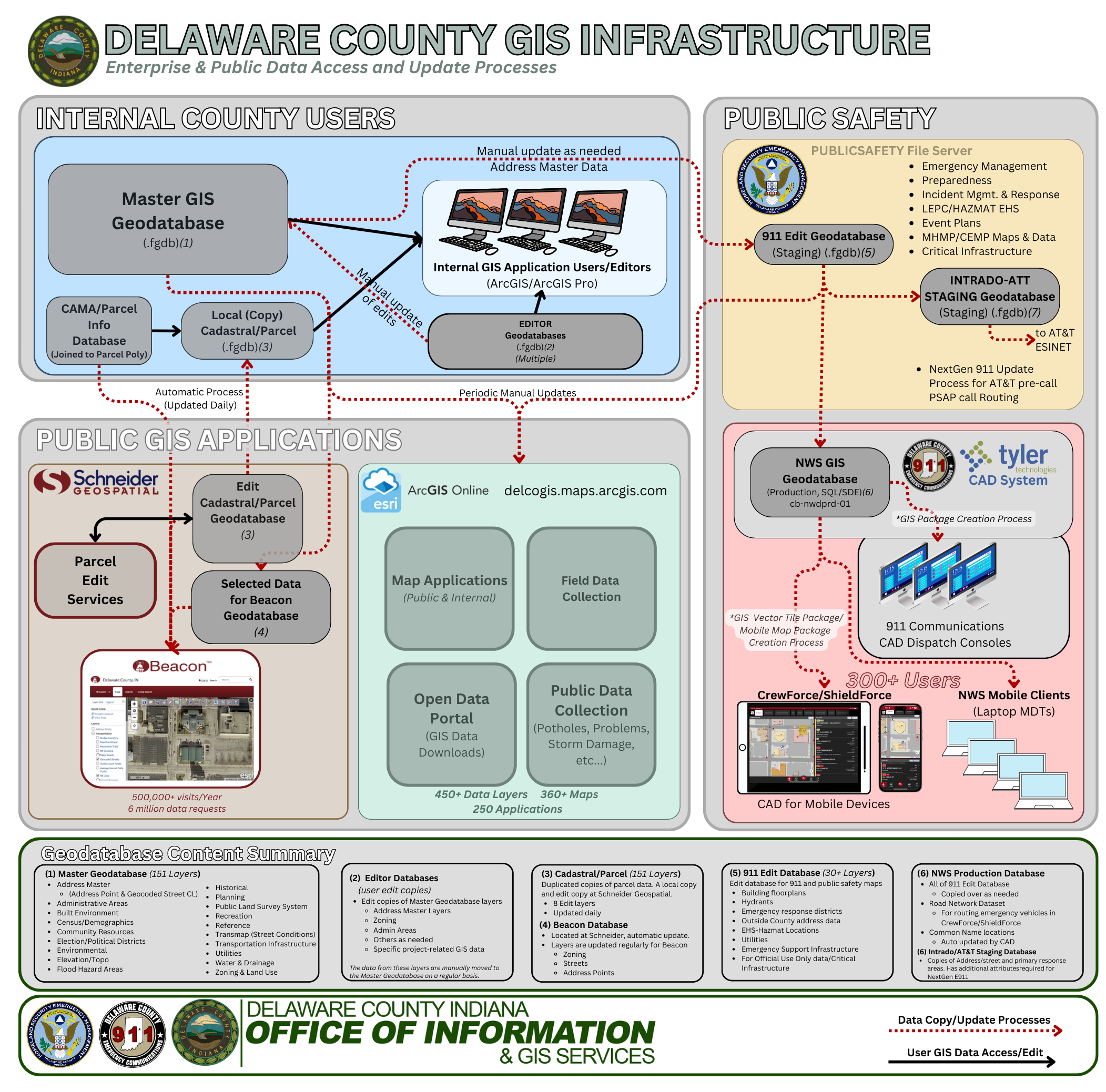
This schematic shows how GIS is distributed and maintained throughout local government and how it is made
available to the public and private sectors.
Emergency Management/911 Communications & Public Safety
The GIS System plays a key role in Delaware County Public Safety System. The Joint City-County 911 Dispatch Center has integrated the County GIS data into their dispatch software (CAD) which is critical in locating every 911 call, determining the appropriate responding agency that is responsible for that location, and allows the dispatcher to give detailed information about the area around the call. This has been essential in locating lost persons, routing emergency services to rural areas, assisting SWAT operations, and identifying adjacent hazards to large incidents like fires. The OOI-GIS Department ensures data in the Dispatch software GIS Databases and maps are as up-to-date as possible. Extensive coordination with the various public safety jurisdictions ensures information within their area is current.
First Responders in Delaware County have access to the Public Safety CAD system in their vehicles through MDT (mobile Data Terminals) or tablets with the CrewForce or Shield Force Applications. These applications provide a very detailed view of our County (and beyond) that includes everything a first responder may need to know about an incident location such as addresses, fire hydrants, fire department connection locations, chemical hazard locations, and much more. Over 70 individual map layers comprise the map, covering the 13 counties in Indiana District 6, with over 3.5 million map features.
The Emergency Operations Center (EOC) is located adjacent to the dispatch center. The Chief Information Officer also serves as the Logistics Section Chief. The EOC is fully GIS-enabled and is capable of displaying multiple maps, video feeds, and informational boards.
Emergency Management-related GIS data of various types is also created and maintained by the GIS DEpt. Data such as Extremely Hazardous Substance (EHS) locations are kept up to date in order to have an idea of where potential hazards lie within our community. Other data like community disaster shelters, critical infrastructure, and areas prone to natural disasters and maintained for planning purposes. In addition, all EMA staff has a mobile web-based map available to them at all times with important information such as critical infrastructure and other important mapping data that is useful during emergencies.
Emergency Management-related GIS data of various types is also created and maintained by the GIS DEpt. Data such as Extremely Hazardous Substance (EHS) locations are kept up to date in order to have an idea of where potential hazards lie within our community. Other data like community disaster shelters, critical infrastructure, and areas prone to natural disasters and maintained for planning purposes. In addition, all EMA staff has a mobile web-based map available to them at all times with important information such as critical infrastructure and other important mapping data that is useful during emergencies.
Planning
The Delaware-Muncie Metropolitan Plan Commission works very closely with the GIS Office. GIS users create and maintain key GIS data for uses such as master planning, zoning, addressing, transportation, and other project-specific uses. GIS maps and data are used in every Board of Zoning Appeal case, as well as many Plan Commission Board meetings.
The Delaware-Muncie Metropolitan Plan Commission works very closely with the GIS Office. GIS users create and maintain key GIS data for uses such as master planning, zoning, addressing, transportation, and other project-specific uses. GIS maps and data are used in every Board of Zoning Appeal case, as well as many Plan Commission Board meetings.
Community Projects and Organizations
The GIS Office provides GIS and technical support for various community projects, non-profit organizations, and community groups.
The GIS Office provides GIS and technical support for various community projects, non-profit organizations, and community groups.
Local Government Decision-Making
The GIS office provides maps and data to elected officials, boards, and commissions in order to better understand the issues and circumstances involved in making important decisions for their constituents. Maps and GIS analysis help provide a better common operating picture, reduce confusion and misinformation and help improve the efficiency of the decision-making process.
The GIS office provides maps and data to elected officials, boards, and commissions in order to better understand the issues and circumstances involved in making important decisions for their constituents. Maps and GIS analysis help provide a better common operating picture, reduce confusion and misinformation and help improve the efficiency of the decision-making process.
Land Records
The GIS Cadastral database contains information related to land records in Delaware County. Many offices, including the Assessor, Auditor, Engineer, Plan Commission, and Surveyor use this information on a daily basis. In the private sector, Realtors, title companies, private land surveyors, and the public can access this information though the Beacon website.
Economic Development
The Delaware County GIS Office supports the Delaware-Muncie Economic Development Alliance with many GIS services related to helping promote the City of Muncie and Delaware County to bring in new businesses and investments. The GIS office also provides general informational maps for the Economic Development website showing the county's location in relation to regional economic markets, proximity to higher education institutions, and local transportation systems.
The Delaware County GIS Office supports the Delaware-Muncie Economic Development Alliance with many GIS services related to helping promote the City of Muncie and Delaware County to bring in new businesses and investments. The GIS office also provides general informational maps for the Economic Development website showing the county's location in relation to regional economic markets, proximity to higher education institutions, and local transportation systems.
Community Development
The GIS dept provides technical assistance to the Muncie Community Development Office. GIS data highlighting project areas, vacant and abandoned buildings, and historical preservation areas are just a few of the maps and datasets that are compiled.
The GIS dept provides technical assistance to the Muncie Community Development Office. GIS data highlighting project areas, vacant and abandoned buildings, and historical preservation areas are just a few of the maps and datasets that are compiled.
Property Assessment
Aerial imagery plays a key role in making sure assessment for property taxing purposes is fair and accurate. Delaware County typically acquires new aerial imagery every other year, and has high-resolution imagery back to 1999.
Aerial imagery plays a key role in making sure assessment for property taxing purposes is fair and accurate. Delaware County typically acquires new aerial imagery every other year, and has high-resolution imagery back to 1999.
- Recent
News - Events
- Useful
Links
Upcoming Events
- Good Friday - County Offices Closed
Apr 03 | All Day - Primary Election - County Offices Closed
May 05 | All Day - Memorial Day - County Offices Closed
May 25 | All Day - Independence Day Holiday - County Offices Closed
Jul 03 | All Day - Labor Day - County Offices Closed
Sep 07 | All Day
Useful Links
- Delaware County Surveyor Embraces GIS Technology to Improve Drainage Management
- Who to Call in Delaware County
- Enhanced Public Safety Through Comprehensive GIS Mapping in Delaware County, Indiana
- Delaware County GIS Open Data
- Delaware County GIS Online Map Gallery
- Property Owner GIS Analysis Maps
- Delaware County Muncie Interactive Visitor's Guide Map
- GIS Layer List
