Delaware County, Indiana
Discover Delaware County - an east central Indiana community of opportunity


Contact Us

Chief Information Officer
- Phone: (765) 213-1269
- Staff Directory
- Office Hours:
8:30am-4:00pm Monday- Friday
Appointments are Required.
Call 765-213-1269
In this Department
Beacon Online GIS Maps
Online Maps & Apps
Parcel Mapping Information
|
SPECIAL NOTICES:
The Office of Information and GIS Services is located in the Emergency Operations Center which is a secured facility, and is open by appointment only. You can send questions or appointment requests to kjohnson@co.delaware.in.us or call 765-213-1269 during regular hours (8:30am-4pm) to speak with staff.
Basic printed Property Maps can still be obtained through the Delaware-Muncie Metropolitan Plan Commission. Specific questions related to property/parcel boundaries should be addressed to the Auditor's Plat room at 765-747-7717.
|
The GIS Parcel database is one of hundreds of Delaware County's GIS data layers, but is probably one of the most important for local government functions. It allows government offices, citizens, realtors, and title companies to quickly and easily locate properties and owners. The database is linked to Delaware County's CAMA (computer aided mass appraisal) system, so users can access data associated to the parcel, such as owner, property and owner address, deed record and page, legal description, assessment information,building sketch and tax information, and much more.
Cadastral?
The parcel database is referred to as a "Cadastral" GIS layer. A cadastral map is a map showing political and surveyed boundaries as well as ownership of land. Our cadastral line layer shows parcel ownership lines, as well as original platted lot lines, subdivision lines, section lines, township lines, railroad and road right of way, water body lines, and misc lines.
Parcel lines are color coded by line type for easy viewing. Labels are displayed for parcel number, lot number, dimensions, and many other items. The display scheme is designed to build upon the original paper plat maps so users who are comfortable viewing them will have no problems migrating to the digital version.
The GIS Parcel database IS NOT A LEGAL SURVEY! It is simply a graphic representation of property boundaries created to improve the efficiency of which land information is retrieved. If you feel the parcel boundaries for your property are incorrect, please contact the Office of Geographic Information to correct the issue. It should not be used for property line disputes. A licensed land surveyor is the only legal way of determining parcel boundaries. We can only change the location of parcel lines if a legal survey, legal description or deed is provided.
Parcel maps are available to the public though the Beacon online mapping service. It is available free of charge, and has the ability to search by address, parcel number, and owner name. Simple prints of properties can be created, both in html and pdf formats. All Delaware County and some City of Muncie offices that deal with land records have direct access to the GIS parcel database and use it on a daily basis.
The Delaware County GIS system was created over two decades ago for the sole purpose of creating a digital county-wide parcel layer. As the project progressed, more and more data was created to compliment and enhance parcel creation. As this additional map layers were created, other government offices and agencies began to see value in the GIS system, and wanted map and data products for their offices. Within 5 years, the GIS system had grown into a robust, county-wide database of over 100 data layers, and was being used for functions from community planning, economic development, and emergency management. Unfortunately, all of these additional requests and tasks did not help speed along the parcel creation project. Software and data format changes, dozens of interns and part time GIS technicians, and other issues plagued the parcel project. Finally in 2003, the decision was made to hire an outside company, that specialized in parcel projects to complete and convert the existing digital parcel database into the a new tag-line parcel data model. This powerful format allows for easier editing and maintenance, as well as a multi-layer approach that enhances the viewing and search ability of the database. The Sidwell Company, of Chicago, Illinois delivered the parcel database in late 2006. The GIS office worked to bring the dataset up to date, as a dozen new subdivisions were built in the 3 years of the conversion project.
About GIS
How is GIS used in Delaware County?
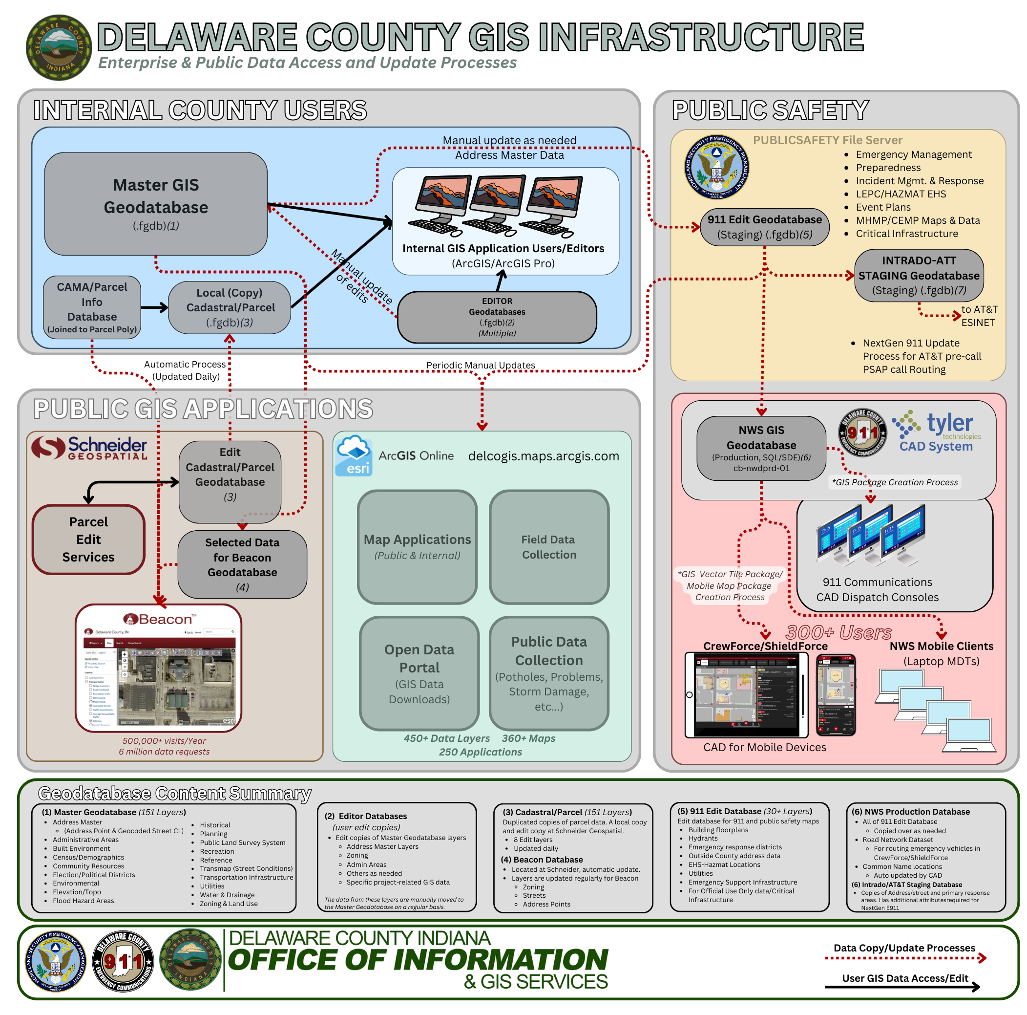
This schematic shows how GIS is distributed and maintained throughout local government and how it is made
available to the public and private sectors.
The GIS System plays a key role in Delaware County Public Safety System. The Joint City-County 911 Dispatch Center has integrated the County GIS data into their dispatch software (CAD) which is critical in locating every 911 call, determining the appropriate responding agency that is responsible for that location, and allows the dispatcher to give detailed information about the area around the call. This has been essential in locating lost persons, routing emergency services to rural areas, assisting SWAT operations, and identifying adjacent hazards to large incidents like fires. The OOI-GIS Department ensures data in the Dispatch software GIS Databases and maps are as up-to-date as possible. Extensive coordination with the various public safety jurisdictions ensures information within their area is current.
First Responders in Delaware County have access to the Public Safety CAD system in their vehicles through MDT (mobile Data Terminals) or tablets with the CrewForce or Shield Force Applications. These applications provide a very detailed view of our County (and beyond) that includes everything a first responder may need to know about an incident location such as addresses, fire hydrants, fire department connection locations, chemical hazard locations, and much more. Over 70 individual map layers comprise the map, covering the 13 counties in Indiana District 6, with over 3.5 million map features.
Emergency Management-related GIS data of various types is also created and maintained by the GIS DEpt. Data such as Extremely Hazardous Substance (EHS) locations are kept up to date in order to have an idea of where potential hazards lie within our community. Other data like community disaster shelters, critical infrastructure, and areas prone to natural disasters and maintained for planning purposes. In addition, all EMA staff has a mobile web-based map available to them at all times with important information such as critical infrastructure and other important mapping data that is useful during emergencies.
The Delaware-Muncie Metropolitan Plan Commission works very closely with the GIS Office. GIS users create and maintain key GIS data for uses such as master planning, zoning, addressing, transportation, and other project-specific uses. GIS maps and data are used in every Board of Zoning Appeal case, as well as many Plan Commission Board meetings.
The GIS Office provides GIS and technical support for various community projects, non-profit organizations, and community groups.
The GIS office provides maps and data to elected officials, boards, and commissions in order to better understand the issues and circumstances involved in making important decisions for their constituents. Maps and GIS analysis help provide a better common operating picture, reduce confusion and misinformation and help improve the efficiency of the decision-making process.
Land Records
The GIS Cadastral database contains information related to land records in Delaware County. Many offices, including the Assessor, Auditor, Engineer, Plan Commission, and Surveyor use this information on a daily basis. In the private sector, Realtors, title companies, private land surveyors, and the public can access this information though the Beacon website.
The Delaware County GIS Office supports the Delaware-Muncie Economic Development Alliance with many GIS services related to helping promote the City of Muncie and Delaware County to bring in new businesses and investments. The GIS office also provides general informational maps for the Economic Development website showing the county's location in relation to regional economic markets, proximity to higher education institutions, and local transportation systems.
The GIS dept provides technical assistance to the Muncie Community Development Office. GIS data highlighting project areas, vacant and abandoned buildings, and historical preservation areas are just a few of the maps and datasets that are compiled.
Aerial imagery plays a key role in making sure assessment for property taxing purposes is fair and accurate. Delaware County typically acquires new aerial imagery every other year, and has high-resolution imagery back to 1999.
Services
Welcome to GIS Services
The Delaware County Office of Geographic Information handles advanced custom map requests requiring geo-spatial analysis and complicated mapping tasks.
We ask that you take advantage of the Beacon GIS website for property-related map questions, or our ArcGIS Online Maps for your specific mapping needs.
If your map request requires more than the Beacon or ArcGIS Online websites can provide, we are available to create a custom map project for you. Depending on the complexity of your request and requires the creation of new digital data, an initial charge and hourly rate may be applied to your final map cost. Please see the pricing schedule page.
Due to limited staff resources, expect a 5-day turnaround for custom maps to be completed.
Any information from the Delaware County GIS Database may be layered on maps at no cost. See the GIS Data & Layers page for a complete list.
GIS and Mapping Links
City of Muncie, Indiana government site with links to various departments.
Muncie Sanitary District City of Muncie sanitary district.
Delaware County Emergency Management Agency Protecting the Citizens of Delaware County of all hazards
Ball State University A large supporter of DCGIS, providing students and interns for over 8 years from the Departments of Natural Resources and Environmental Management, Geography and GIS, and the College of Architecture and Planning.
IGIC- Indiana Geographic Information Council Coordination of Indiana GIS through dissemination of data and data products, education and outreach, adoption of standards, and building partnerships.
USGS United States Geological Survey- As an unbiased, multi-disciplinary science organization that focuses on biology, geography, geology, geospatial information, and water, we are dedicated to the timely, relevant, and impartial study of the landscape, our natural resources, and the natural hazards that threaten u
IGS Indiana Geological Survey
The mission of the Indiana Geological Survey is to provide geologic information and counsel that contribute to the wise stewardship of the energy, mineral, and water resources of the state.
White River Watershed Project is an EPA section 319 Grant to Delaware County Soil & Water Conservation District to reduce non-point source water pollution in the Upper White River Watershed in Delaware County.
Green Map Organization International Organization promoting the identification and mapping of Sustainable Practices in the Community. The Delaware County version of the Green map has taken various forms over the last several years, most recently redesigned by Andrew Fritz and his classmates from Martha Hunt's Landscape Architecture LA 604 Regional Planning Class. The project is currently seeking funding for mass production of the map.
Environmental Research Systems Institute (ESRI) Industry leading developer and manufacturer of advanced Geographic In formation Systems software.
Cardinal Greenway "Changing Indiana Through Neighborly Connections"
Managing agency for the Cardinal Greenway and White River Greenway multi-use recreation trails.
Muncie-Delaware Economic Development and Chamber of Commerce Extensive information on demographics, taxes, business incentives, available buildings and sites, utilities, workforce, education, health care, arts and entertainment, cultural and recreational activities, visitor information, relocation assistance, permitting, cost of living, existing business and Chamber of Commerce programs, and much more.
STATS Indiana Comprehensive depository of Census and socio-economic data that is easily searched and viewed.
A Kid's Glossary of map & GPS Terms with links for Kid's geography activities.
History of GPS and Transportation Learn about how the GPS system came to be and how it has changed over the last 50 years. This resource includes many links with information all about GPS Satellites, how they work and much more. A special thank you to Amelia who mentioned that this would be a great resource to share on our website!
Open Data Hub
Visit Delaware County and Muncie community's public platform for exploring and downloading open GIS data, discovering and building apps, and engaging to solve important local issues. You can analyze and combine Open Datasets using maps, as well as develop new web and mobile applications. Let's make our great community even better, together!
- Recent
News - Events
- Useful
Links - Services
Upcoming Events
- Good Friday - County Offices Closed
Apr 03 | All Day - Primary Election - County Offices Closed
May 05 | All Day - Memorial Day - County Offices Closed
May 25 | All Day - Independence Day Holiday - County Offices Closed
Jul 03 | All Day - Labor Day - County Offices Closed
Sep 07 | All Day
Useful Links
- Sign Up to Receive Emergency Alerts from Delaware County Emergency Management
- Delaware County Indiana Enhances River Safety with New Mile Marker System on the White River
- Video PSA - Severe Weather Awareness with Delaware County Emergency Management
- Delaware County Surveyor Embraces GIS Technology to Improve Drainage Management
- Who to Call in Delaware County
- Delaware County Attractions - A StoryMap
- Enhanced Public Safety Through Comprehensive GIS Mapping in Delaware County, Indiana
- Closure of County Road 650 East for Bridge Replacement - Starting Feb 19th, 120 day closure.
- INDOT 511IN.org TrafficWise Road Conditions Map
