Skip over navigation


Start Content
Delaware County, Indiana
Discover Delaware County - an east central Indiana community of opportunity
Contact Us

Kyle Johnson,
Chief Information Officer
Chief Information Officer
- Phone: (765) 213-1269
- Staff Directory
- Office Hours:
8:30am-4:30pm
Lunch Hour varies, call for appointment.
In this Department
Parcel Mapping Information
SPECIAL NOTICES:
The Office of Information and GIS Services is located in the Emergency Operations Center which is a secured facility, and is open by appointment only.
The Office of Information and GIS Services is located in the Emergency Operations Center which is a secured facility, and is open by appointment only.
You can send questions or appointment requests to kjohnson@co.delaware.in.us or call 765-213-1269 during regular hours (8:30am-4pm) to speak with staff.
Basic printed Property Maps can still be obtained through the Delaware-Muncie Metropolitan Plan Commission. Specific questions related to property/parcel boundaries should be addressed to the Auditor's Plat room at 765-747-7717.
GIS Parcel Database
The GIS Parcel database is one of hundreds of Delaware County's GIS data layers, but is probably one of the most important for local government functions. It allows government offices, citizens, realtors, and title companies to quickly and easily locate properties and owners. The database is linked to Delaware County's CAMA (computer aided mass appraisal) system, so users can access data associated to the parcel, such as owner, property and owner address, deed record and page, legal description, assessment information,building sketch and tax information, and much more.
The GIS Parcel database is one of hundreds of Delaware County's GIS data layers, but is probably one of the most important for local government functions. It allows government offices, citizens, realtors, and title companies to quickly and easily locate properties and owners. The database is linked to Delaware County's CAMA (computer aided mass appraisal) system, so users can access data associated to the parcel, such as owner, property and owner address, deed record and page, legal description, assessment information,building sketch and tax information, and much more.
Cadastral?
The parcel database is referred to as a "Cadastral" GIS layer. A cadastral map is a map showing political and surveyed boundaries as well as ownership of land. Our cadastral line layer shows parcel ownership lines, as well as original platted lot lines, subdivision lines, section lines, township lines, railroad and road right of way, water body lines, and misc lines.
Parcel Symbology
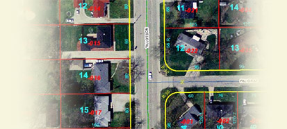
Parcel lines are color coded by line type for easy viewing. Labels are displayed for parcel number, lot number, dimensions, and many other items. The display scheme is designed to build upon the original paper plat maps so users who are comfortable viewing them will have no problems migrating to the digital version.
Parcel lines are color coded by line type for easy viewing. Labels are displayed for parcel number, lot number, dimensions, and many other items. The display scheme is designed to build upon the original paper plat maps so users who are comfortable viewing them will have no problems migrating to the digital version.
Parcels and Surveys
The GIS Parcel database IS NOT A LEGAL SURVEY! It is simply a graphic representation of property boundaries created to improve the efficiency of which land information is retrieved. If you feel the parcel boundaries for your property are incorrect, please contact the Office of Geographic Information to correct the issue. It should not be used for property line disputes. A licensed land surveyor is the only legal way of determining parcel boundaries. We can only change the location of parcel lines if a legal survey, legal description or deed is provided.
The GIS Parcel database IS NOT A LEGAL SURVEY! It is simply a graphic representation of property boundaries created to improve the efficiency of which land information is retrieved. If you feel the parcel boundaries for your property are incorrect, please contact the Office of Geographic Information to correct the issue. It should not be used for property line disputes. A licensed land surveyor is the only legal way of determining parcel boundaries. We can only change the location of parcel lines if a legal survey, legal description or deed is provided.
Availability and Use
Parcel maps are available to the public though the Beacon online mapping service. It is available free of charge, and has the ability to search by address, parcel number, and owner name. Simple prints of properties can be created, both in html and pdf formats. All Delaware County and some City of Muncie offices that deal with land records have direct access to the GIS parcel database and use it on a daily basis.
Parcel maps are available to the public though the Beacon online mapping service. It is available free of charge, and has the ability to search by address, parcel number, and owner name. Simple prints of properties can be created, both in html and pdf formats. All Delaware County and some City of Muncie offices that deal with land records have direct access to the GIS parcel database and use it on a daily basis.
History
The Delaware County GIS system was created over a decade ago for the sole purpose of creating a digital county-wide parcel layer. As the project progressed, more and more data was created to compliment and enhance parcel creation. As this additional map layers were created, other government offices and agencies began to see value in the GIS system, and wanted map and data products for their offices. Within 5 years, the GIS system had grown into a robust, county-wide database of over 100 data layers, and was being used for functions from community planning, economic development, and emergency management. Unfortunately, all of these additional requests and tasks did not help speed along the parcel creation project. Software and data format changes, dozens of interns and part time GIS technicians, and other issues plagued the parcel project. Finally in 2003, the decision was made to hire an outside company, that specialized in parcel projects to complete and convert the existing digital parcel database into the a new tag-line parcel data model. This powerful format allows for easier editing and maintenance, as well as a multi-layer approach that enhances the viewing and search ability of the database. The Sidwell Company, of Chicago, Illinois delivered the parcel database in late 2006. The GIS office worked to bring the dataset up to date, as a dozen new subdivisions were built in the 3 years of the conversion project.
The Delaware County GIS system was created over a decade ago for the sole purpose of creating a digital county-wide parcel layer. As the project progressed, more and more data was created to compliment and enhance parcel creation. As this additional map layers were created, other government offices and agencies began to see value in the GIS system, and wanted map and data products for their offices. Within 5 years, the GIS system had grown into a robust, county-wide database of over 100 data layers, and was being used for functions from community planning, economic development, and emergency management. Unfortunately, all of these additional requests and tasks did not help speed along the parcel creation project. Software and data format changes, dozens of interns and part time GIS technicians, and other issues plagued the parcel project. Finally in 2003, the decision was made to hire an outside company, that specialized in parcel projects to complete and convert the existing digital parcel database into the a new tag-line parcel data model. This powerful format allows for easier editing and maintenance, as well as a multi-layer approach that enhances the viewing and search ability of the database. The Sidwell Company, of Chicago, Illinois delivered the parcel database in late 2006. The GIS office worked to bring the dataset up to date, as a dozen new subdivisions were built in the 3 years of the conversion project.
- Recent
News - Useful
Links - Services
Useful Links
- Press Release: Delaware County Indiana Homeland Security and Emergency Management Agency Acquires Programmable Sign Trailer with Support from Ball Brothers Foundation
- Delaware County GIS Open Data
- Delaware County GIS Online Map Gallery
- Property Owner GIS Analysis Maps
- Delaware County Muncie Interactive Visitor's Guide Map
